Alerts

About Grampanchayat Mangrul Chawala

History of Mangrul Chawala

A Legacy of Heritage

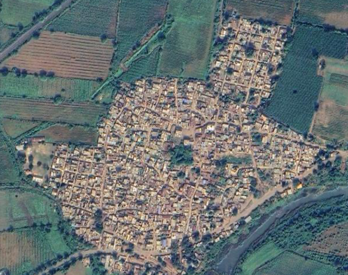
Mangrul Chawala is a historically rooted village in the Nandgaon Khandeshwar Taluka of Amravati district, Maharashtra. The region draws its historical significance from the ancient Khandeshwar Temple, constructed in 1255 CE during the Yadava dynasty under the reign of Ramachandra Yadava. The village has evolved over centuries — from its time under the Yadavas, through the Maratha and British periods, to its present identity as a thriving farming community in the heart of Vidarbha.

The nearby Khandeshwar Temple — built under the legendary Hemadri Pandit in the Hemadpanthi style using interlocking black basalt stones without mortar — stands as a proud symbol of the region's medieval engineering excellence. This magnificent Shiva temple has endured for nearly 770 years and remains an active pilgrimage and cultural landmark near Mangrul Chawala, drawing devotees from across the Vidarbha region.

1255

Yadava Dynasty

Khandeshwar Temple constructed

1722

Maratha Period

Bhonsle ki Amravati established

1859

British Era

Included in East Berar District

1947

Independence

Acceded to Bombay State (post-independence)

Village Map
Political Map of Mangrul Chawala Village

Vision & Mission

Our Vision

To transform Mangrul Chawala into a self-sufficient, model Gram Panchayat that exemplifies sustainable agriculture, transparent governance, quality education, and empowered communities.

  • Implement all Central & State Government schemes effectively
  • Water security, conservation & Jal Jeevan Mission
  • Sustainable cotton-based & eco-friendly agriculture

Our Mission

  • Provide transparent, accountable, and citizen-centric governance
  • Ensure effective implementation of all government schemes
  • Promote sustainable agriculture and water conservation
  • Empower women, youth, and marginalized communities
-->

Information & Demographics

4,224 Total Population
967 Total Households
92.5% Literacy Rate
943 Sex Ratio
92% Tax Collection
₹16.51 L Annual Budget

Demographics Details

Census Data

Particulars Total Male Female
Total Population 4,224 2,174 2,050
Children (0-6 years) 171 74 97
Scheduled Caste (SC) 434 216 218
Scheduled Tribe (ST) 60 31 29
Literate Population 3,906 2,065 1,845
Illiterate Population 318 109 205

Harni Village Demographics

461 Total Population
126 Total Households
79.6% Literacy Rate
889 Sex Ratio

Harni - Demographics Details (Census 2011)

Census 2011 Data

Particulars Total Male Female
Total Population 461 244 217 (47.1%)
Children (0-6 years) 48 33 15 (31.3%)
Scheduled Caste (SC) 84 (18.2%) - -
Scheduled Tribe (ST) 0 (0.0%) - -
Literate Population 367 (79.6%) 192 175 (38.0%)
Working Population 45.1% - -

General Village Information

Key facts and figures about Mangrul Chawala village

Location & Administration

Village Name Mangrul Chawala
Gram Panchayat Mangrul Chawala
Taluka Nandgaon Khandeshwar
District Amravati
Distance from Taluka 22 km
Distance from District HQ 50 km

Land & Agriculture

Geographical Area 1,057.13 Ha
Soil Type Black Soil (Vertisols)
Main Crops Cotton, Soybean, Tur, Gram, Wheat
Other Crops Moong, Vegetables
Main Occupations Agriculture & Animal Husbandry

Social Demographics

Total Population 3,763
Total Households 1,001
SC Population 333
ST Population 462
Literacy Rate 78.77%
Social Structure Good and harmonious

Political Representatives

Assembly Constituency Dhamangaon Railway
Assembly MLA Pratap Adsad
Lok Sabha Constituency Amravati (SC)
MP Balwant Baswant Wankhade (INC)

Postal & Market Info

PIN Code 444708
Post Office Mangrul Chawala (BO)
STD Code 07222
Nearest Market Nandgaon Khandeshwar and Amravati mandi
Railway Station Badnera Junction (Amravati)

Facilities & Infrastructure

Electricity Available (18 hrs Domestic, 12 hrs Agri)
Drinking Water GP Water Supply + Jal Jeevan Mission
Road Connectivity Pucca (State Highway 294)
Public Transport Bus service available (linking to taluka HQ and Amravati)
PHC Available at Taluka HQ & Shirajgaon

पायाभूत सुविधा

मंगरूळ चव्हाळाची कृषी, पाणी, स्वच्छता आणि मूलभूत सेवा

🌾

कृषी सुविधा

  • उन्हाळा आणि हिवाळा दोन्ही ऋतूमध्ये १२ तासांचा नियोजित कृषी विद्युत पुरवठा उपलब्ध असून शेतकऱ्यांना पिकानुसार सिंचनाचे योग्य नियोजन करता येते.
  • गावात एकूण १०५७.१३ हेक्टर भौगोलिक क्षेत्रापैकी सुमारे ८०४ हेक्टर शेती क्षेत्र (७५९ हेक्टर बागायती आणि ४४ हेक्टर जिरायती) असून त्यात कालवा, बोअरवेल/ट्यूबवेल आणि पावसावर आधारित शेती पाहायला मिळते.
  • कापूस, सोयाबीन, तूर, हरभरा तसेच भाजीपाला व फळबागा ही प्रमुख पिके घेतली जातात.
  • ठिबक व तुषार सिंचन, शेततळे आणि पावसाचे पाणी साठवण प्रकल्पांच्या माध्यमातून जलसंधारण व आधुनिक शेती पद्धतींचा अवलंब करण्यावर भर दिला जात आहे.
💧

पिण्याचे पाणी व जलव्यवस्था

  • गावात वर्षभर नियमित नळाद्वारे पिण्याच्या पाण्याचा पुरवठा केला जातो, तसेच उन्हाळ्यातही आवश्यकतेनुसार पाणी उपलब्ध राहते.
  • नळाच्या पाण्याबरोबरच विहिरी, हँडपंप आणि ट्यूबवेल या अतिरिक्त स्रोतांमुळे गावाची जलसुरक्षा अधिक मजबूत बनली आहे.
  • ग्रामपंचायत पातळीवर जलसंधारण, पाण्याचा कार्यक्षम वापर आणि स्वच्छ पाणी वापराबाबत जागरूकता निर्माण करण्यासाठी विविध उपक्रम हाती घेण्यात येत आहेत.
🚮

स्वच्छता व कचरा व्यवस्थापन

  • मंगरूळ चव्हाळा हे स्वच्छ भारत अभियानांतर्गत हागणदारीमुक्त (ODF) दर्जा प्राप्त केलेले गाव आहे. प्रत्येक घरात शौचालय सुविधा उपलब्ध आहे.
  • गावात घराघरातून कचरा संकलनाची सेवा उपलब्ध असून रस्त्यावरील कचरा गोळा करण्यासाठीही स्वतंत्र व्यवस्था करण्यात आली आहे.
  • नाल्यांचे जाळे व जलनिस्सारण व्यवस्था गावातील घनकचरा व्यवस्थापन आणि स्वच्छता राखण्यासाठी ग्रामपंचायत सातत्याने मजबूत करत आहे.
🛣️

इतर सुविधा व विकासाच्या संधी

  • मंगरूळ चव्हाळा हे पक्क्या रस्त्यांनी नांदगाव खंडेश्वर तालुका मुख्यालय (२२ किमी) आणि अमरावती शहराशी (सुमारे ५० किमी) चांगले जोडलेले आहे.
  • १८ तासांचा घरगुती वीजपुरवठा नियमित असून डिजिटल सेवा, ऑनलाईन शिक्षण आणि कृषीविषयक माहिती यांचा वापर गावकऱ्यांकडून वाढत्या प्रमाणात केला जात आहे.
  • भविष्यात कापूस कृषि-प्रक्रिया केंद्र, सौर छत प्रतिष्ठापना, घनकचऱ्याचे वर्गीकरण व कंपोस्टिंग युनिट आणि शेतकरी उत्पादक संघटना (FPO) मंगरूळ चव्हाळाचा सर्वांगीण विकास वेगवान करतील.

Administrative Codes

Official codes and identifiers for Mangrul Chawala

🏛️

Official Identifiers

Census ID 8119
LGD Code / Village Code (Census 2011) 533142
Gram Panchayat Code (MNREGA) 1824006469
Block Code 63
Block Name Nandgaon-Khandeshwar
Sub-District (Tehsil) Code 4012
Sub-District HQ Mund Nishankrao
District Code (Amravati) 503
State Code (Maharashtra) 27

MNREGA Employment Data

Cumulative MNREGA data (2013–2018) · Source: Government of India MNREGA Portal

Job Cards

Total Job Cards Issued 916
Active Job Cards 65

Workers

Total Workers Registered 2,061
Active Workers 75

Work & Wages

Total Persondays Generated 2,943
Total Wage Payments ₹4.26 Lakh

Educational Overview

Mangrul Chawala has a literacy rate of 78.8% (Census 2011), reflecting our ongoing commitment to education

Zilla Parishad School

2

Anganwadi Centers

5

Total Students Enrolled

72
🎓

Colleges near Mangrul Chawala

Adarsh Junior College

Vasant Dada Patil Junior College, Salod Kajaba

Kala Mahavidyalay Wadhona Ramnath

Address: At. Wadhona Ramnath, Tq. Nandgaon (Kh), Dist. Amravati

🏫

Schools in Mangrul Chawala

Madhyamik Vidyalaya

Address: Mangrul Chawala, Nandgaon Kh, Amravati, Maharashtra, 444708

Z P Primary School

Address: Mangrul Chawala, Nandgaon Kh, Amravati, Maharashtra, 444708

Literacy Statistics

2,627
Total Literate
1,452
Male Literate
1,175
Female Literate

Financial Overview

Fiscal Year 2024-25

₹16.51 Lakh Total Budget
₹2.50 Lakh Government Grant

Budget Allocation

Water Supply 30%
₹4.95 Lakh
Sanitation 25%
₹4.13 Lakh
Roads & Infrastructure 28%
₹4.62 Lakh
Administration & Other 17%
₹2.81 Lakh

Village Facilities & Connectivity

Polling Stations / Booths

  • 1 G.P. Prayamari Marathi Shala Room No. 1, Kohla Jateshwar
  • 2 G.P. Prayamari Marathi Shala Room No. 3, Kharda
  • 3 G.P. East Madhyamik Shala Room No. 2, Salod
  • 4 G.P. East Madhyamik Shala Room No. 1, Javara Molvan
  • 5 G.P. East Madhyamik Shala Room No. 3, Mangrul Chawala

How to Reach Mangrul Chawala

🚂

By Rail

No railway station within 10 km. Nearest stations:

  • Badnera Junction Railway Station (near Amravati)
  • Amravati Railway Station
🚌

By Road

Mangrul Chawala has good road connectivity: State Highway 294 links it to Nandgaon Khandeshwar (15 km) and Amravati city (approximately 50 km).

Govt. Health Centers Near Mangrul Chawala

SC

Manjari Mhasla

Sub Center (SC)
PHC

Mangrul Chawala

Primary Health Centre (PHC)

Near Gram Panchayat Mangrul Chawala

SC

Hiwra Buzruk

Sub Center (SC)

Gram Panchayat Hiwra Buzruk

Meet Our Gram Panchayat Members

निलेश निंबर्ते
सरपंच

श्री. राजेश हनुमंतराव पारधी

📞 ९६२३०००८१६

शोभाताई चव्हाळाे
उपसरपंच

सौ. निखील नागोराव देशमुख

📞 ९३०९९५६१३५

आर.जी. राबडे
ग्राम सचिव

श्री. आर.जी. राबडे

📞 ९४२३२३४९९५

पंचायत सदस्य

निखील देशमुख
सदस्य

श्री. निखील नागोराव देशमुख

📞 ९३०९९५६१३५

लक्ष्मीताई खांडेकर
सदस्या

सौ. लक्ष्मीताई पंकज खांडेकर

📞 ८८३०१७८१३५

सुनिताताई टेवरे
सदस्या

सौ. सुनिताताई ईश्वर टेवरे

📞 ९६०७३५५६९४

अश्विनीताई चव्हाळाे
सदस्या

सौ. अश्विनीताई विनोद चव्हाळाे

📞 ९५५२४०२९९५

अतुल ठाकुर
सदस्य

श्री. अतुल मोहनसिंह ठाकुर

📞 ८४५९२२१४३७

रेशमाताई शिरभाते
सदस्या

सौ. रेशमाताई भुषण शिरभाते

📞 ९४०३१५००१३

रामदास कोचडे
सदस्य

श्री. रामदास नागो कोचडे

राजेश पारधी
सदस्य

श्री. राजेश हनुमंतराव पारधी

📞 ९६२३०००८१६

सविताताई झोपाटे
सदस्या

सौ. सविताताई सुरेश झोपाटे

📞 ९०९६८७४५००